Regional Transportation Planner for the City Region of Arnhem and Nijmegen, Netherlands, Sorjs Van Duren (his first name sounds kind of like George if that helps!) gave us a few lessons – his key wish for us to know:
- our community is same as your community
- language matters
- regional traffic concerns strongly affect local traffic concerns
Our community is same as your community
We have a strong affinity to our cars and definitely to our parking! Highway travel in Netherlands is better than in any other European nation – according to Sorjs!
Sound familiar?
This affects budgeting, community conversations, and roadway designs. Large public works budgets are allocated to highway and large arterial projects. So we work on the margins and get good walking and bicycling infrastructure in place with each of those projects.
And yet, despite this approach, there are well-used protected bike lanes on all arterial/collector streets, and an amazing network of shared use paths that carry many trips. Coupled with plentiful underpasses and overpasses their bicycling network carries 30% of the region’s traffic. Trains and buses carry about 18% and cars handle about 52% of all trips.
There are several small towns here that comprise this rural region. Mook is 7,806. Cuijk is 25,000. 11,600. Linden is just under 1,000. Their big population center is Nijmegen at 170,000. Nijmegen has a University as well as the regional hospital. Most jobs, both factory, service, University, and Hospital jobs are in Nijmegen, making the regional commute an issue for all communities. And their main difficulty is that jurisdictions for units of government do not match commuting patterns – so there is no one governmental agency that can help make commutes smooth. The regional governmental agency is the best, but it doesn’t have authority within each city/county/transit district, etc. But it can act as the communicator and get agencies talking together.
Their regional plans classify some routes as key car routes, and others as key bike routes. The key car routes get focused attention on reducing delays and congestion through access management, signal coordination, and other efficiencies. One efficiency they look at is adding crosswalk islands to cross pedestrians without need for pedestrian signals to decrease delays for both modes.
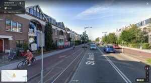
Example Saint Anna Straat (S105)
sorry for the poor quality – but trace the arterial that connects Mook, Molenhoek, and Malden to downtown Nijmegen. That route, S105, St. Anna Street, when it hit Nijmegen, was a 4- and 5-lane arterial. It still has some sections where it is still that wide.
It had a lot of congestion through Nijmegen because it was trying to be a local arterial (service driveways, local streets, turns on and off, as well as carry regional trips. It didn’t operate well for any mode of traffic. ROW is 70′.
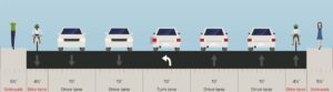
5-Lane Road in 70′ provides a difficult street to cross, as well as ride or walk along.
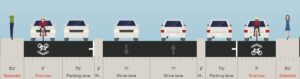
The reconfigured St. Anna Street close to downtown Nijmegen, where volumes on the corridor are the highest, is now just 2-lanes – the city eliminated left turns, and gained capacity by reducing any conflicts with turns. Any side entrances (driveways or local streets) were converted to Right In and Right Out. Minor street intersections that have signals were enhanced to 2-phase signals as those have more capacity than 3-phase signals (no left turn phase and the lost time associated with that), and the side frontage roads provide on-street parking, ways into and out of side streets, and a low-volume, low-speed shared road bikeway facility that has a lower level of stress than the previous 4′ bike lane on a 5-lane road. Of course, at the busy street intersections they end the frontage roads and on-street parking, move to a simple protected bike lane, and use the extra space to add left and right turn lanes as needed. The City moves more people with this configuration than ever before and delays to car traffic have decreased significantly. Corridor travel times have decreased and capacity increased. They looked at it simply as a traffic engineering equation – how could they move the most cars and the most people. Benefits to abutting properties are the quieter access, large buffer to fast moving street, and street trees.
The frontage roads created a nicer separation for the homes and businesses from the busy State Highway route, St. Anna Street which leads directly into the heart of town and the train station. The flexibility gained on the frontage streets allows street trees to soften the harsh highway edge, making it a much more livable and functional street, even though it now carries more people. Eliminating conflicts for the road, allows it to operate at a higher level of service, with fewer crashes, fewer delays, according to Sorjs Van Duren, a regional transportation planner with the City Region of Arnhem and Nijmegen.
Language Matters
One of Sorjs favorite projects is a high quality, all-ages and all abilities bike route that connects the small towns that commute into downtown Nijmegen for work, shopping, play, medical, and university trips. At first his team called it the Bicycling Super Highway. The term highway had negative connotations for the rural communities he was targeting. High speeds, freight, noise, pollution. Those were the thoughts of the folks he talked to about the project. But they changed the name to the Bike Path that Just Allows You to Keep Going – it’s got a lot catchier Dutch word, but this is the translation into English!
He recalled a conversation with an elderly lady at a farmer’s market where he had the project booth. And she was so thankful he wasn’t moving forward with that highway project. She was really excited to be able to bike along a slow-speed pathway.
It was the same project. With the same design features. But Sorjs has learned that when he talks to Farmers he learns their values, what is important to them, and frames his project to relate to their needs. When he talks to the freight haulers, same thing – what is important to them, how can he craft a project that meets their needs, when he talks to politicians he finds their ambitions and emotional pulls and crafts his project to meet their needs.
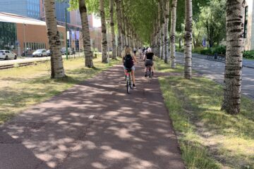
The end result is a bicycling route that small town community members can use to bike for recreation, exercise, and to get to the “big town” of Nijmegen to avoid congestion and parking issues. The bike path meanders through woodland forest, along farmers fields with cows and horses and goats, over rivers, along rail and along highway (but only for short stretches), and then uses St. Anna Street’s shared lane frontage roads to reach the heart of Nijmegen.
We rode one of these routes and it was a very easy route, and saw people of all ages and abilities. Most of the length of the route had no stops – any roadway crossings were prioritized for the path. There were two that were prioritized for the road – one was a heavy freight route, and another a prioritized car route. At both there were islands set up to cross just one lane of traffic at a time and good sight lines. No cars or trucks yielded, so folks waited for gaps in traffic. Once in town, you travel quite a few blocks without a traffic signal, but eventually you catch a red light that you stop at. But it moves you quite quickly.
The region all worked to fund it, particularly the bridges, where he sought funding from $500,000 to $1,000,000 from 11 different local agencies. With funding from the national government (different pots of money from Health funds, to Equity funds, to Air Quality funds, and Climate funds) he was able to fund it completely. There are a few other regional cycling routes in the area that bring trips into Nijmegen every day. The one we rode in on has about 6,000 bicycling trips a day.
Regional Traffic Affects Local Traffic
When looking to protect livability, the city and region identify which streets need to carry more people, and which should be restricted to residential traffic. They increase people moving capacity of the busy streets, and add modal filters along the routes of cut-through traffic to break the ability of people to intrude in residential areas.
They also create effective traffic calming on the residential streets to make sure residents are safe and comfortable within their own neighborhoods.
1 Comment
David Green · July 11, 2022 at 3:47 am
I’d like to learn more about St Anna street when you get home. Would a design like that work on 3rd street and on Greenwood east of 3rd?