We went to an afternoon training with James Thoem, Copenhagenize. He helped explain how Copenhagen increased bicycling mode share, decreased VMT and congestion, and decreased the number of injury crashes in their town even as population and bike miles traveled increased as the town grew. Here is his article, and I’ve just summarized some of the highlights and other things he explained in the class.
Really this process took them about 10 years, although they’ve been inching along for a while, but their main bicycling infrastructure has been built within the last 10 or so years.
Four main typologies of bike system facilities in Copenhagen depending on the volume and speed of traffic (moving from low speed/low volume to higher as you go down the list):
- Shared Space – almost all local streets fall into this category (although occasionally some local streets are critical bike routes, so even though there is low volumes/speeds they might still designate a bike lane) (these roads do not have sharrows). Note they also have many local streets that have traffic calming and modal filters (cars can’t pass all the way through, but people walking and biking can), but not all – most of their local streets naturally have low volumes and speeds.
- Painted lanes – can include parked car protection.
- Curb raised, separated track – can also include parked car protection.
- Buffered plantings, railings and fences. – these are for alongside the really fast routes.
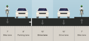
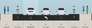
Standard Widths
7′ wide is the standard curb separated bike lane width.
The design of the curb separated bike lane is just slightly elevated above the road, while the sidewalk is just slightly elevated above the bike lane. Curb reveals are short – just 1 to 2″ reveal curb heights. This allows some additional utility/flexibility for emergency vehicle use because EMS can just easily roll over the curb. Also easy to bike into road, or onto sidewalk with such a short reveal curb.
7′ allows people riding to pass each other.
If pinched, they’ll allow narrower, but still protected, raised bike lane in order to continue the protected route continuity.
If anticipating more bike riders, they’ll work to widen the bike lane to 8′, 9′, 10′, 12′ etc.
Travel Lanes
10′ travel lanes for lefts, throughs, rights, bus lanes, heavy truck usage, etc. They’ll allow wider or narrower depending on the context. We’ve seen some wider travel lanes where there is a minor need for on-street parking but it is not formally allowed – they assume the person will park half on the road and half on the protected bike lane to accommodate quick deliveries, etc. We’ve seen narrower approaching a crosswalk safety pedestrian island, and also within local streets (queuing streets).
Cross-sections
Copenhagen requires protected bike lanes on each side of the street (arterials and collectors), even when the street is one-way (in this case one of the bike lanes will be a contra-flow protected bike lane).
Contra flow bike lane – one way roads can have 1 or 2 lanes
The left-turn lanes are usually really short, 1 car storage and very short taper in – to allow flex space along the corridor. ROW widths can be wider when there is need for right turn lanes, wider bike lanes, and wider sidewalks. Right turn lanes are also typically fairly short – just a 100′ feet or less.
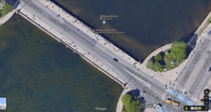
Critical bridge – especially after a new inner harbor bridge was constructed about 1 mile south of here. In 2011? the city revised the lanes (after the new inner harbor bridge was built). It used to be a 4 lane road with narrow sidewalks and narrow bike lanes. It wasn’t working for anyone. Now it is 2 travel lanes with wide protected bike lanes and wide sidewalks. The volumes served now? 45,000 people cross this bridge on bike every day – yes – they reduced the number of travel lanes yet increased how many people were served. There is a sign that displays real-time bike counts. We witnessed it turn over past 2 Million people on bikes served since 1/1/2022 (this week was nearing the end of June, 2022).
Development Ideas
Copenhagen city permitting requires developments to extend protected bike lanes all the way to their site and also require on-site bike routes to connect the protected bike lane network all the way to the front doors or parking areas. Same for transit stops (require the development to construct the stops and the transit service provider to provide service from phase 1 of the development). Same with Metro rail lines – the developments place a fee on the apartment, paid annually or monthly that can last up to 100 years to pay off the cost to extend the rail line to the new developments. This occurs with master planned areas.
1 Comment
David Green · July 11, 2022 at 3:25 am
It will be great to try some of these ideas for protected bike lanes in Bend. The parking protected bike lanes could be put in many places just be striping the road differently.