Bike Lanes
Oregon has been installing bike lanes on arterial and collector roadways since the 1970’s. Because of this, Bend has an almost complete network of bike lanes that provides pretty complete coverage and access throughout the community.
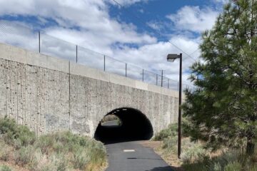
Because there are only a few gaps in this bike lane network, bike lanes in Bend attract many riders. Here are some daily bike counts on different bike lanes: 60 people bike on the Colorado Avenue Bridge; 275 people bike through the Franklin tunnel; and 400 people ride over the Galveston Avenue Bridge every day. But there are still so many folks that don’t choose riding a bike. One reason could be stress level. The city’s bike lanes are most likely high stress when the speeds are posted 35 mph.
For anyone just starting out riding a bicycle to go somewhere, riding in a bike lane on a road posted 35 mph or higher is like trying to learn to ski or snowboard on the blue or black runs up at Mt. Bachelor Ski Resort. When you just take up skiing or snowboarding, you start on the bunny hill and progress slowly to the Marshmallow run before taking on even the Flying Dutchman run. It is an easy analogy that to get folks used to riding, you start them on easier routes.
Low Stress Bicycling
What makes a route easy for anyone to ride their bike on? The needs are relatively straightforward: separation or buffering from traffic, easy crossings of busy streets, and routes that are well-integrated into the community that can easily connect them from where they live to where they want to go. So, what does Bend have that is easier than basic bike lanes?
Luckily, Bend has a tremendous start on a connected network of great community bicycling facilities that includes 65 miles of urban trails, 6.7 miles of shared use paths along roadways, and 10 miles of neighborhood greenways. These are routes that are comfortable for most adults and young people.
The trick for Bend, now, is to connect these easiest bike routes into a cohesive network. Which is what the City’s Transportation System Plan lays out for the community. The Low Stress Bicycling Network (LSN) does not have a catchy name, but it maps low stress bikeways and identifies projects needed to fill in the gaps to create a connected network of easy routes. Once it is built out, most homes in Bend will have a low stress bicycling route within 1/4 mile of their home and can take low-stress routes all the way to where they want to go.
How is the City of Bend building its planned LSN?
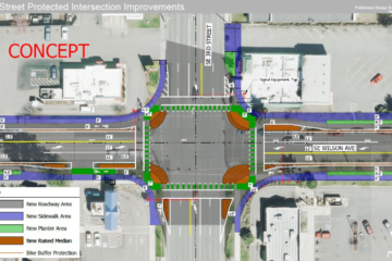
Updating Standards. In 2022, Bend updated its standards and specifications requirements for low-stress buffered bike lanes, protected bike lanes, and shared use paths in lieu of sidewalk for all arterial and collector roadways. Bend has a long history building shared use paths to serve schools with the Central Oregon Community College getting a shared use path along Newport Avenue in the 1960’s and Cascade Middle school getting a shared use path along NW 14th Street in the 1970’s. With the new standard to require shared use paths along all new/reconstructed arterials and collectors, Bend is getting back to its roots. Shared use paths along the new corridors of Murphy Road, Empire Avenue, and Century/14th create a separated place to ride your bike on their shared use paths.
Converting Basic Bike Lanes to Buffered Bike Lanes. Basic bike lanes are being converted to buffered bike lanes with pavement overlay projects. Each year the City overlays one or two collector or arterial roadways. The City is also working to add a buffer stripe whenever feasible with the summer striping program. At this rate, it is possible that most bike lanes in Bend will be converted to buffered bike lanes within 10 years.
Creating Neighborhood Greenways. Neighborhood Greenways are an attainable way to add Low Stress Network Routes to fill in critical gaps in the easy bicycling network. Neighborhood Greenways are marked on a local, typically residential street, and have slower speeds (20 mph) and less cars.
Multiple Partners. Bend is fortunate to have several public agencies working together to build the LSN. Each agency is integrating safe and comfortable bike riding facilities with new construction, reconstruction, and pavement preservation projects.
ODOT has already constructed several segments of trails along US 97 through town, along the Cascades Lakes Highway, and continues to provide critical bicycling infrastructure along US 20 and US 97 including buffered bike lanes, shared use paths, and critical over- and under-passes of its urban highways. One key project for ODOT is the North Corridor Project which re-routes US 97 north of Empire Avenue and will build a shared use path parallel to the highway; and is looking to build a shared use path under or over the highway and railroad to connect the neighborhood to the east easily to the mall and area shopping centers. The Oregon Department of Transportation is an industry leader in bicycling policies and facilities design. ODOT has several initiatives to continue to build better bike facilities including adopting Low Stress Bicycling Guidelines in 2018 and the Blueprint for Urban Design adopted in 2020.
Bend Park and Recreation District provides 65 miles of trails in Bend and builds more trails each year. Bend has a great opportunity for trails along irrigation canal ditch rider roads. Gaining public easements for these ditch rider roads would be highly beneficial to the broader community to provide really safe routes that anyone can use.
Even the Bend LaPine School District adds trails across their property when they add new buildings or create new schools.
Have you ridden Bend’s trails, shared use paths, or neighborhood greenways?
0 Comments